
InstantAtlas
Deliver data, information and research about your area
We help people present data about areas in effective and efficient ways to provide a context for decision making.
We do this by creating and delivering innovative services and software to simplify and enhance the management and presentation of geography and statistics.
We started with the InstantAtlas Desktop. We now prepare and manage large statistical indicator data sets in ArcGIS Online and deliver community information systems, local observatories and knowledge hub websites for our clients.
We also make available bundles of the apps that we use internally - Data Catalog and Report Builder+ - so that you can build your own services and sites using ArcGIS Online.
Either way you get easy-to-use web sites with attractive and engaging reports.
Licensing & Deployment
- Cloud Hosted
- Windows
- Mac
- Linux
Support
- Chat
- Phone
Knowledge Base
- Help Guides
- Video Guides
- Blogs
Media
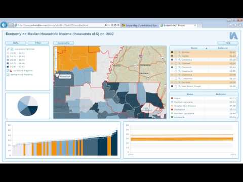
InstantAtlas Core Features
Focus of Data Visualization Feature
- Dashboard
- Data Import/Export
- Data Management
- Data Mining
- Relational Display
- Simulation Models
- Visual Discovery
InstantAtlas Pricing
Pricing Type
- Contact Vendor
Free Version
- No
Free Trial
- 30 Days Trial
Payment Frequency
- Quote Based
InstantAtlas Reviews

This profile is not claimed
Do you own or represent this business? Enter your business email to claim your Goodfirms profile.