How often do people check their weather app? They may look at it once a day to choose an outfit or plan their route to work.
At the same time, businesses in the agriculture, supply chain, retail, and energy sectors depend on the weather to stay profitable. For them, weather-driven analytics plays a key role in mitigating business risks, responding to customer demand, and planning sustainable operations.
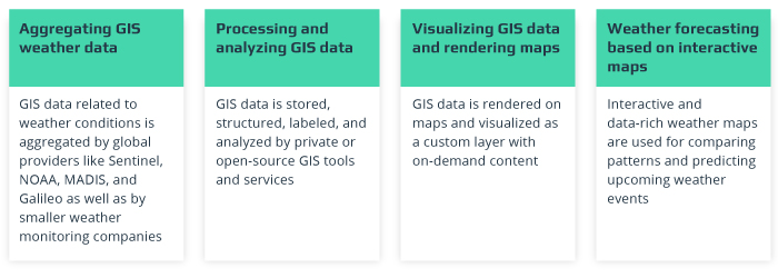
Monitoring and predicting weather is impossible without collecting high volumes of weather-related data and visualizing it on interactive maps. Geographical Information Systems (GIS) are an essential part of big data meteorology. GIS software can recognize geographic patterns hidden in data on environmental factors that influence the weather.
Common Approach to Weather Analytics
The most important part of weather analytics is collecting accurate data on environmental conditions that can indicate upcoming weather changes. The main sources of this data are meteorological stations, satellite images, and IoT sensors installed onshore and offshore.
Offshore stations are very important, as the most critical weather changes originate from the oceans. Cyclones move with hot and cold streams, determining weather across the earth.
Equipment for big data meteorology captures data on wind speed and direction, temperature, humidity, and atmospheric pressure, together with the geographic location of this data.
Weather data is merged with coordinates using GIS mapping tools to compare visualized information on weather conditions over a period of time. In such a way, weather forecasting providers can track cyclones’ movement to predict the weather in a certain region over the next few days.
Global service providers, sometimes even small companies who develop their own solutions for weather monitoring and forecasting, collect data on weather conditions in huge databases for further analysis.
Weather forecasters like AccuWeather, Meteoblue, and Metos make semi-manual predictions based on rich historical data and recent environmental changes. They provide public weather forecasts on their websites that can be used by businesses for more specific predictions.
Other companies like DTN offer business-oriented weather predictions. For example, DTN provides weather insights into the energy sector to help companies avoid electricity disruptions and plan sustainable networks.
A higher volume of data results in higher accuracy of weather predictions, which is important for end customers, especially for business environments where a mistake may cost millions in revenue, not to mention hinder a timely response to natural disasters and cost human lives. The next big steps for accurate and localized weather predictions are using the most relevant data, visualizing it as interactive map layers using GIS mapping tools, and applying AI weather forecasting methods.
What Is GIS and What Role Does It Play in Weather Analytics?
Geographical Information Systems (GIS) deal with all geographical and spatial data that may be captured from the world around us and applied to various fields, from construction to drone navigation.
In particular, GIS for weather monitoring is part of the larger disaster management field covering the evacuation of affected areas and minimization of weather-related risks. GIS data related to weather-determining conditions is usually represented by geographical coordinates of weather-related measurements, recognition of their movement patterns, and analytics of possible changes visualized on interactive maps.
GIS analytics is used for monitoring a wide range of weather conditions. GIS mapping tools help weather forecasting services match weather data with geographical coordinates to locate and visualize weather conditions, making it possible to predict how weather events may change or move over time.
Conditions for Efficient Weather Analytics Based on GIS Data
- Data sources have to be reliable, relevant, and trustworthy
- Map rendering should be fast, and maps should be easy to publish
- Map layers should be interactive to track dynamic changes
- All data should be rapidly updated based on regular data flows
- Maps should be smoothly integrated with other business apps
Weather forecasting services that pay attention to these requirements for weather maps and GIS data can track past and present weather events and predict future events to empower businesses with valuable insights into how the weather may affect their assets.
How Does GIS Weather Analytics Work?
There are several large providers of weather-related GIS data collected from a global network of stations and sensors. Sentinel, NOAA (the National Oceanic and Atmospheric Administration), MADIS (the Meteorological Assimilation Data Ingest System), and Galileo are the most prominent leaders in this field.
There are also companies like FTS that create their own software and hardware stations deployed in far-to-reach and dangerous areas to monitor and predict natural disasters and critical weather changes by applying GIS technologies.
Companies like ESRI, a global provider of ArcGIS and other GIS data analytics services, and tools, maintain cloud databases used to create custom map layers based on enriched and recent geospatial data. These layers can be updated with custom content, including weather conditions, to use them as inputs for accurate forecasts.
The GIS mapping tools market is commonly divided into private and open-source tools and services to analyze GIS data related to weather conditions and come up with insightful map visualizations. Often, these GIS tools are offered by global providers like ESRI. However, this doesn’t exclude the possibility for smaller companies to develop their own custom solutions based on ArcGIS or PostGIS services or using open-source GIS development tools.
Basic Steps of GIS Weather Analytics
For businesses, GIS data insights can accelerate weather-driven analytics. GIS technology gives geographers and business analysts a way to visualize accurate weather data and correlate it with their business assets geographically. It also ensures a large amount of geospatial data can easily be visualized based on certain criteria and a custom set of requirements to find out exact patterns critical to a business.
Businesses in the agriculture, supply chain, energy, and retail sectors have weather-vulnerable assets across the globe. GIS analytics helps them monitor potential threats and meteorological hazards and provides actionable insights on how to limit or eliminate those threats or calculate potential losses.
GIS Weather Analytics Meets Business Needs
GIS analytics data can be accessed via an open API for direct integration with specific custom software for businesses. Servers with GIS data on weather conditions can provide ready-to-use visualized information as map layers or stream GIS data right to an in-house proprietary weather monitoring system used by the end customer.
GIS-driven weather analytics finds applications across various industries, offering untapped opportunities for making business-critical decisions faster.
Agriculture
The agriculture industry is one of the most illustrative examples of an industry greatly affected by the weather. Due to the direct hazards to crop yields posed by drought, lack of irrigation, heavy rains, high winds, and other weather events, agribusinesses must take out insurance against their crop yields.
Geoinformatics in agriculture is a part of precision farming and helps agribusinesses forecast yields with 96% accuracy. As agribusinesses deal with a large number of fields located in different areas, they require accurate localized weather forecasts. This is especially important in light of the recent trend in predicting RoI per field, as each field may perform differently.
GIS data plays a crucial role in weather prediction by saturating field maps with custom weather layers to show the exact location of potentially affected fields.
To increase the precision of agriculture weather predictions, agricultural companies and farmers can use connected sensors installed directly in their fields to measure weather conditions. They can also rely on satellite and drone imagery to monitor weather changes and their impact on crops by applying geoinformatics in agriculture.
Weather can also affect animals, influencing livestock management. For example, heavy rain can result in less milk from cows; strong winds can distract animals and make them feel sick. Situations like these require immediate action from farmers as well as planning and budgeting for agribusinesses.
It may sound odd, but insurance plans for agribusinesses can be as valuable an asset as nutrients and sunlight. Agribusinesses often rent equipment or have to pay in advance for seeds, irrigation, and nutrients, all of which will be wasted if weather kills the crops.
To secure these expenses, agribusinesses take out loans that include insurance coverage. Based on GIS weather predictions, insurance companies can be more responsive to the needs of agribusinesses and offer better coverage for severe weather.
Retail
The impact of weather on customer demand for particular products and delivery services is a subject of interest among retailers worldwide. In particular, behavioral patterns become apparent during severe weather conditions or natural disasters.
A one-day shutdown of stores in New York can lead to $152 million in lost retail sales. At the same time, when customers can’t go to buy goods, they order delivery services. As another example, GIS-driven analytics of weather patterns helped RaceTrac, a US-based retail company, predict changes in customer traffic due to severe weather events with 99% accuracy across 370 stores nationwide.
Supply Chain
Logistics for heavy equipment and big shipments often depend on several means of transportation, including trucks, airplanes, ferries, and ships. Smartly planning routes to save cargo from damage or delays in the estimated time of arrival also requires predicting the weather.
While planning transportation across the ocean, weather forecasting means a lot both to shippers and receivers. Integrating GIS weather analytics with logistics solutions, traffic management systems, and route planning software makes supply chains more reliable and responsive to current and upcoming weather events.
Energy
Weather Decision Technologies (WDT) enables its partners to build apps for specific industries like energy and utilities. WDT integrates weather prediction services into end customers’ apps using GIS weather mapping to predict energy consumption and smartly distribute power across the energy grid.
Weather analytics also empowers smart building and facility management systems to cut utility costs by accurately forecasting weather to decrease heating of premises. Forecasting weather changes can also help to prepare electricity lines for potential lightning and avoid energy disruptions.
What Is the Future of GIS Mapping Tools for Weather Predictions?
GIS analytics for weather prediction stands in quite an interesting position. Basic GIS technologies have already been established on the market, as have data-driven approaches among businesses.
GIS analytics is a perfect match for weather-dependent businesses. Still, there are a lot of adjustments that could be made in terms of providing a seamless user-experience and integrating with advanced AI, cloud, and IoT technologies.
Cloud Computing
More businesses require seamless integration via open APIs to saturate their systems with GIS weather data, and cloud technology provides a flexible and reliable infrastructure to make integrations much easier.
The amount of GIS data is only increasing, raising the demand for scalable development environments and storage. Cloud computing empowers weather forecasting providers to deploy GIS analytics tools, data, and maps within one environment as well as to run several instances to compare analytics and come up with the most accurate settings.
SaaS Business Model
Another trend that can reinforce GIS weather analytics is the shift from private on-premises solutions to open-source and SaaS (Software as a Service) business models. These models don’t require customers to buy expensive technology but allow them to use only necessary functionality on a subscription basis.
Artificial Intelligence
The introduction of advanced technologies like machine learning and AI weather forecasting can lead to more accurate and faster. For now, weather forecasters are providing semi-automated predictions.
Businesses often receive automated GIS data updates and data-rich maps only to wait for a manually built forecast from meteorological services. This level of automation is far from perfect.
Using machine learning techniques to teach algorithms to distinguish between current weather conditions and predict upcoming events based on historical data will accelerate business decisions as well as responses to potentially life-threatening hazards.
Internet of Things
The impact of the Internet of Things (IoT) on geospatial analysis will be seen in the years to come together with the wider adoption of smart infrastructure and connected cars. Cities will become huge aggregators of data, including weather data.
The connectivity and computing power of portable devices will increase the efficiency and rapidity of weather-driven insights delivered right to users’ smartphones, houses, and cars. This will prevent potential traffic jams and even reduce the number of storm victims by notifying drivers to avoid risky areas or stay at home.
Conclusion
The combination of weather and spatial data plays an important role in predicting weather and preventing risks to business profits and peoples’ lives. Advanced GIS analytics tools empower businesses to see hidden patterns by making them visible on interactive maps.
Maps enriched with weather data visualized by GIS analytics tools are becoming a critical asset, allowing businesses across industries to make weather-driven decisions.
The use of GIS software helps in weather-driven business analytics. You can get your custom software developed by Intellias.